5.9 magnitude earthquake rattled Indonesia; No fatalities or injured were reported
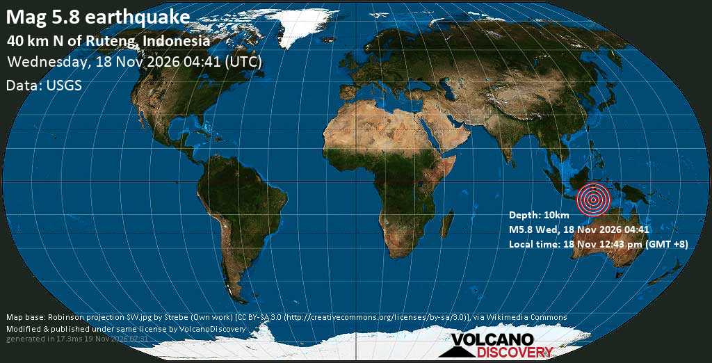
A strong earthquake struck Indonesia's East Nusa Tenggara province on Wednesday, November 18, 2026, with tremors felt across nearby communities on the island of Flores. The German Research Centre for Geosciences (GFZ) recorded the earthquake at magnitude 5.9, while the United States Geological Survey put it at 5.8 following manual revision. Both agencies reported a depth of 10 kilometers, with the epicenter in East Manggarai Regency, around 41 km from the town of Ruteng.
Modelled estimates from the USGS suggest that more than 1.2 million people across Indonesia may have felt the earthquake. Of those, roughly 24,900 were in areas where shaking was likely to have reached intensity VI, or strong, on the Modified Mercalli scale, while another 10,700 may have experienced the highest expected intensity of VII, or very strong. These figures come from automated impact models based on population distribution and predicted ground motion rather than from observations; direct felt reports from the region have so far numbered in the dozens, mostly from Labuan Bajo, 76 km west of the epicenter.
The strength of the modelled shaking raised concerns about possible damage in communities near the epicenter. USGS notes that the population in this region generally occupies structures vulnerable to earthquake shaking, predominantly unreinforced brick with concrete floors and precast concrete frame with wall construction, although earthquake-resistant buildings also exist. Recent earthquakes in the area have triggered secondary hazards including landslides.
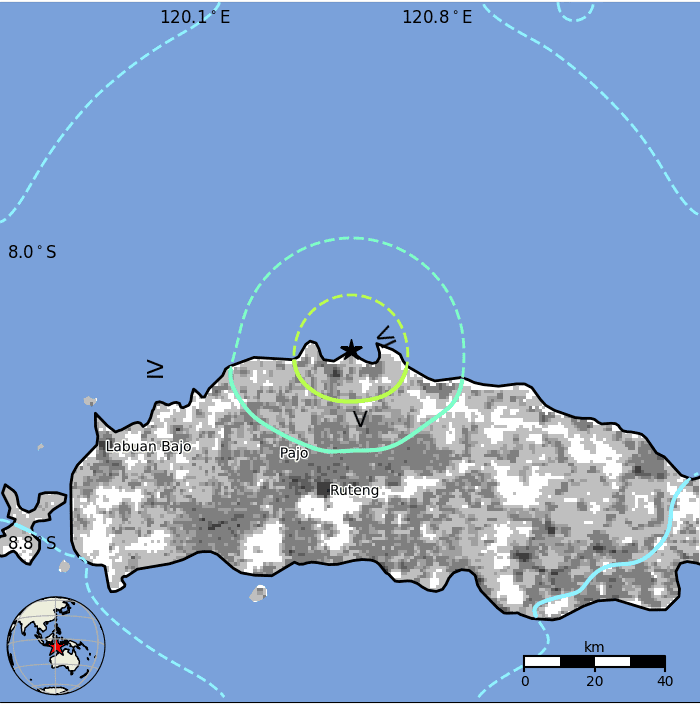
Despite this, early USGS assessments indicate that the earthquake is unlikely to have caused major destruction or significant loss of life. The agency placed it in the green alert category for both fatalities and economic losses, the lowest on its scale, estimating a 90.4% probability that no one was killed directly by the shaking and that total economic losses will not exceed $1 million.
The region has a history of far more damaging events. A magnitude 7.7 earthquake 146 km north of this week's epicenter in December 1992 exposed an estimated 429,000 people to intensity VII shaking and killed 2,519.
In a separate development, GFZ reported another earthquake measuring magnitude 6.0 in the Papua New Guinea region. No connection between the two earthquakes was established in the reports.
Authorities have yet to confirm the full extent of any damage, and GFZ provided no information on potential casualties. For now, the early findings suggest that although the earthquake produced strong shaking across a wide area, the risk of widespread damage and casualties remains low.
Sources: volcanodiscovery.com, timesofindia.indiatimes.com
Want to read more like this story?

Spectacular interchanges around the world
Jun, 20, 2018 | NewsCheck these engineering marvels, built to provide solutions to chronic traffic congestion problems...

Severe storms and possible tornadoes cause widespread damage across North Carolina
Oct, 15, 2026 | NewsSevere thunderstorms and possible tornadoes swept through central North Carolina on Sunday, knocking...

Cairo, Egypt: Building collapse caused 6 casualties while 7 others were injured
Oct, 13, 2026 | NewsOn Tuesday October 13, a five-storey building collapsed in Cairo's Hadayek El-Qobba district, killin...
Glass cafe at 2,600 feet in the air: it opens on world's tallest bridge
Oct, 13, 2025 | NewsThe Huajiang Grand Canyon Bridge was completed in three years and eight months and now links two ma...

The Leaning Tower of Pisa: Ingenious design and ongoing stability efforts
Jun, 19, 2024 | NewsThe Tower of Pisa, since its completion in 1372, has continually leaned. However, due to intentiona...

SDC Verifier 2026 R2 Expands Structural Verification for Offshore, Marine, and Complex Engineering Projects
Sep, 16, 2026 | NewsSDC Verifier 2026 R2 expands structural verification with new offshore and marine standards, multiax...

Complex underground tunnel in Manhattan: The Grand Central–42nd street connection
Oct, 01, 2026 | NewsThe new pedestrian tunnel connecting Grand Central Terminal with the No. 7 subway line at 42nd Stree...

Newcastle’s tallest building reaches its final height
Sep, 25, 2026 | NewsNewcastle’s skyline is getting a major addition, with The Store development in the city’s West End o...

Shipyard Crane Fatigue Analysis with FEA and SDC Verifier
Oct, 08, 2026 | NewsWhere the crane details were exposed to variable-amplitude loading, SDC Verifier used the Palmgren-M...
Trending

Athens, Greece: Building collapsed after explosion

Tulsa’s Williams Crossing Bridge Wins 2026 Bridge of the Year

Dar es Salaam, Tanzania: 13 fatalities due to building collapse
Africa’s longest bridge: Cairo’s Iconic 6th October Bridge