Levee Digital Twin Platform Launches for California's Yuba River Corridor Featured
Researchers at UC Berkeley, funded by Yuba Water, have unveiled the Levee Digital Twin Platform — a comprehensive, interactive monitoring system built for levee inspection and condition assessment along the Yuba River Corridor in Sacramento Valley, California. The platform, accessible at leveedigitaltwin.org, was developed using the EZ Digital Twins service platform, which provided the geospatial data integration, visualization, and sharing infrastructure that made the project possible.
The initiative represents a significant step forward in how engineers and asset managers approach the monitoring of flood defense infrastructure. Rather than relying on periodic visual inspections and manual data collection, the Levee Digital Twin Platform unifies multiple high-resolution data streams into a single, continuously updated digital representation of the levee system.
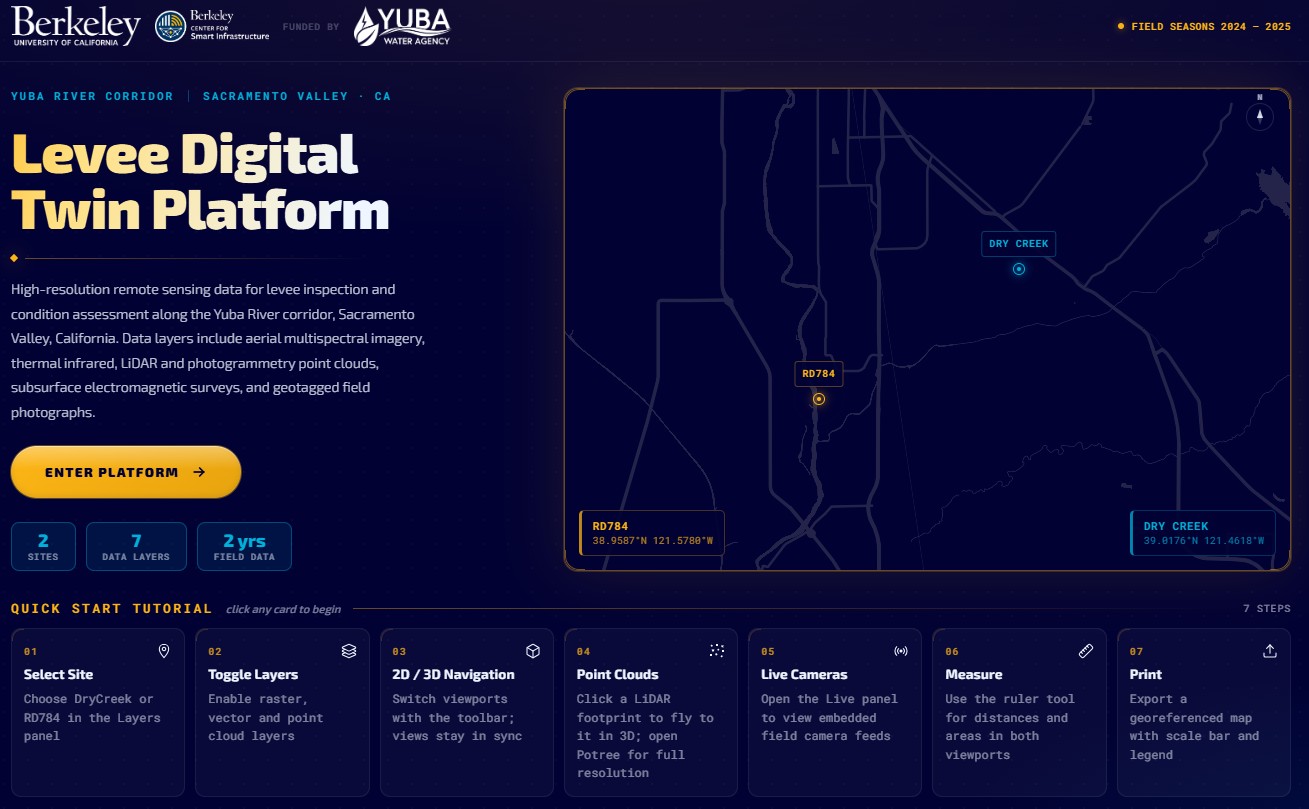
The platform integrates multiple distinct data layers collected across two field seasons between 2024 and 2025, covering two sites — RD784 and Dry Creek — along the Yuba River Corridor. Data layers include aerial multispectral imagery, thermal infrared, LiDAR and photogrammetry point clouds, subsurface electromagnetic surveys, boreholes and piezometer reading, embedded cameras and geotagged field photographs. Users can toggle between 2D and 3D viewports, fly to point cloud models, run measurements, watch cameras and sensors readings and export mapping layouts — all from within a browser-based interface.
Levees are among the most consequential and underleveraged assets in public infrastructure. The levee systems of California's Sacramento Valley protect hundreds of thousands of residents and billions of dollars in agricultural and urban property, yet monitoring has historically lagged behind other critical infrastructure categories. Digital twin technology — combining real-time sensor data, remote sensing, and predictive analytics — offers a path toward earlier detection of seepage anomalies, settlement, and structural degradation, long before conditions become critical.
The Levee Digital Twin Platform demonstrates that this approach is not only technically viable but also practically deployable using existing managed platforms.
The platform is publicly accessible at leveedigitaltwin.org and includes a seven-step quick-start tutorial guiding users through site selection, layer toggling, 2D/3D navigation, point cloud interaction, live camera/sensor feeds, measurement tools, and map export.
EZ Digital Twins as the Enabling Platform
The Levee Digital Twin Platform was built on EZ Digital Twins, a managed geospatial digital twin service designed for infrastructure professionals. EZ Digital Twins handled the integration of multi-modal data — sensors, LiDAR, imagery, and analytics — into a single, interactive environment, removing the need for the research team to build and maintain bespoke backend infrastructure.
More information on the EZ Digital Twins platform is available at ezdigitaltwins.com.
Want to read more like this story?

Digital twins of buildings can contribute to the reduction of environmental carbon emissions
Sep, 15, 2023 | NewsBuildings are responsible for approximately 40% of greenhouse gas emissions in the United States. A...

"Digital Twinning the Built Environment", part of "The future of Infrastructure today!" webinar series
Dec, 20, 2023 | EventLecture date: Friday January 19, 9:00-10:00AM PST "The future of Infrastructure today!” is a monthl...

Bentley Systems Announces Bentley Infrastructure Cloud Connect
Oct, 15, 2025 | NewsBentley Systems, Incorporated, the infrastructure engineering software company, today announced Ben...

DCOdes: A new Platform for Infrastructure Software and Scripts helps you find the right computational tools easier!
Mar, 01, 2023 | NewsA new platform has been launched, with the goal to organize software, codes and scripts used in Des...

A 5D platform for earthquake prevention and control
Nov, 17, 2021 | NewsA five-dimensional (5D) smart city earthquake simulation platform was exhibited by its developer, t...

GIS digital twin - usBIM.geotwin
Oct, 19, 2023 | Software
Digitalization could assist the construction industry reducing its carbon emissions
May, 28, 2024 | NewsIt is well known that the global construction industry significantly contributes to the world's car...

Amsterdam: The World’s first 3D-printed steel bridge
Jul, 26, 2021 | NewsMark Girolami, professor at The Alan Turing Institute, stated that “3D printing is poised to become...

Smart construction: How superstructures are built in just 11 days
Mar, 06, 2025 | NewsThe construction industry has undergone significant changes in recent years as digital transformati...
Form
Looking for more information? Fill in the form and we will contact EZ Digital Twins for you.
Trending

Tall building fire safety in 2026 using AI, BIM and arson research

Altair will be the tallest residential towers in Sri Lanka

Construction of the tallest building in the US delayed due to flight safety concerns

How Big Will Godzilla Be In 2050?

Spectacular interchanges around the world